
This blog is for discussion of Mineral King, Sequoia National Park and related issues. Click on the "xx comments" word below to go to the blog and/or post a new message.
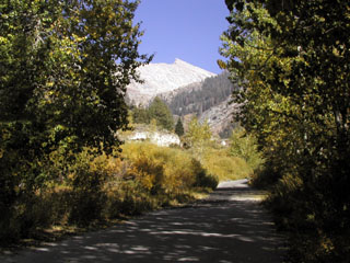
Along the trail to Aspen Flat
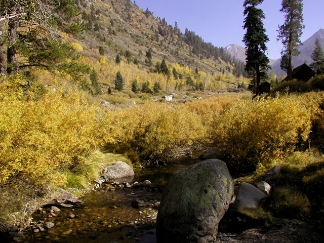
Mineral King Valley, 7830 ft elevation, October 5, 2007 AM
479 comments:
«Oldest ‹Older 401 – 479 of 479Conditions at White Chief and Cirque cave area? Planning hike to Cirque in a week. I would guess most entrances are still plugged. Can't wait to check out the wild flowers.
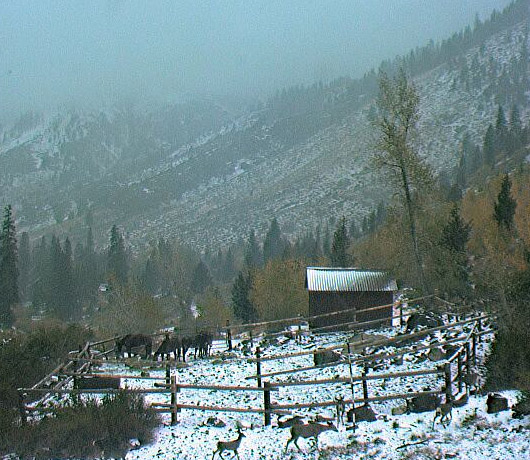
I miss the pack station cam.... it always has deer this time of year. Any idea if it will be back up?
@Mern, The webcam is up and working.
See http://www.mk-webcam.net
The most recent photo is from yesterday.
Snow: Yes
Haha! Mother Nature beat the snow pole this year.
That's a nice look this morning with the fresh dusting of snow and the deer in the corral.
Finally some snow :-) Hope we get a lot more!!
What is that object leaning against the bottom of the corral snow pole??
I believe it is a Christmas decoration that was installed by the Botkins in late December.
Hi Glenn,
Wondering why I can only see the oldest 200 comments and not the remaining 209 as the main page says there are 409 comments? I thought I would let you know.
FYI,
Diamond-X
Retraction,
Nevermind! I logged in to post the question and there are all the comments!
Have a great Spring!
Diamond-X
Wow, 3 feet of new snow in one day--yay!
It looks like the 2012 season is really about here... Have a great summer everyone!
Hurry and check out the Farewell Gap camera... There is a bonus today!
Wow!! That's pretty cool!
So glad there is a MK Webcam so everyone can enjoy seeing the fall colors,they are so pretty this year!
Hello,
In 1975 while backpacking near Mineral King my friends and I observed an aircraft wreckage field beginning at Farewell Gap and extending several hundred yards down the Little Kern River canyon to the south-southeast. Smaller parts were found at the top of the pass, larger parts were found scattered down the canyon including at least one rather large radial engine.
I have always wondered about this crash site but have never been able to find any information about it. Can anybody here tell me anything about it?
Thanks.
I believe its a A4 sky hawk that crashed in the 70s when they used to shoot up the valley, this one didnt make it, I believe the pilot was killed when he missed judged his height. This is no longer allowed because of air restrictions over National Parks. A goggle seach will give you more info...Robert
http://a4skyhawk.org/content/va-127-ta-4j-buno-154636-crash
The A-4 actually crashed by Bullfrog lakes 1969 and the crash in Farwell Gap was a converted AWAC Constellation and that happened in 1970. We have photos of the crash site somewhere. My dad went with the Navy recovery team.
Thanks Unknown. I'm an aerospace engineer and I know the difference between a radial piston and a jet turbine. I do recall at the time I read in a friend's pocket trail guide about a Navy multi-engine patrol plane that crashed there in the 50s or 60s, but haven't seen anything else about it in all these years.
... And I am sorry your Dad had to perform that sorrowful duty. It must have been terrible.
For some reason it's coming up that I'm "unknown" forgot my other login I guess. I also go by Deismanfamily #29 on here. Yes my dad was the ranger on the hill at the time. We also have 8mm movies of the helicopter hauling out debris to Lemoore. I'll post some photo's when I find them. I think they are in my dad's "work" carousel for the slide machine.....my how technology has changed. We have been trying to convert all the old slides to digital format...takes a little time!
incidentally...I brought this up to my dad and he started rattling off crash sites all over the area. Was pretty interesting. I know we have some instruments out of some abandoned crashed aircraft stored in a box somewhere. There is also a practice bomb hanging half out of the ground somewhere on the Sequoia National Monument district. They had to call the Navy about that one too! :)
I found something on the TA-4 2-seat Skyhawk that confirms 1969.
http://www.ocregister.com/articles/one-319237-patty-flight.html
"On Feb. 24, a U.S. Navy Skyhawk, searching for the Gambler's Special, crashed in the high Sierras near Bullfrog Lake. Both men onboard were killed."
Still nothing on the large Navy piston. Was it possibly an EC-121 / WV-2? This is becoming an obsession with me.
http://en.wikipedia.org/wiki/Lockheed_EC-121_Warning_Star
I'm sure it probably was..My dad has always just said a converted Lockheed Constellation....I know I've heard stories of landing gear being rolled down the hill and I've seen a beautiful sculpture hanging over one of the cabin owners fireplaces that they said was melted aluminum from the crash site. I'll look for the photos this week. I've been wanting to post them anyway. My dad also talked about finding the melted pilots wings on one of the recovery missions...sad. We have a friend that was a Blue Angel pilot at the time and he'd buzz the valley from time to time. He always seemed to know how to blow the mantles out of our propane lights!...Miss that!
Fantastic to see the fresh snow, and lots of it! Can't wait for the snow on the lens to melt for a better view. I hope everyone had a Merry Christmas.
The corral snow pole should be moved over slightly. The corral posts in the back are making it hard to read.
Any volunteers?
The snow looks fantastic, BTW
Looks like all the snow on Bear Skin is all gone,wow!!! Now that hardly ever happens!!!! Hope we have a lot of snow this winter!
I went up solo to Farewell Gap on Sat 9-21-2013. The trail is very well-maintained. I remember years ago it had been severely eroded by people taking shortcuts, which can be dangerous in low light. About 2 miles from the Gap, clouds began swirling in right on the trail, the sky blackened, and half-pea-sized hail dropped lightly. At the Gap, though, the clouds parted and it was actually warm! This was an amazing display of the beauty and changing conditions of nature. I stayed for about 10 min on the Gap, taking pictures and examining the old crash site from the trainer jet that barely missed making it over the pass around 1970. Then, just as quickly as it had turned mild, the weather raged: high winds (almost knocking me down), driving hail, and driving rain. The ground turned from grey to white. I was prepared (as you must be, too, when you hike): I had a down parka, a long skullcap that fitted over my ears, eyebrows and neck, and synthetic-plastic gloves over my hands. I headed down and maintained a quick pace (but still safe) to stay warm and switched on my flashlight (also a necessity) at the signed junction b/t the Gap trail and the Lakes trail (4 mi to go). When I came back to my car, it was covered w/ icy slush. This was a great hike that I will remember for its surprise of really inclement weather much earlier in the year than I expected, its beautiful skies, and the timeless beauty and consistency of Farewell Gap. If you go here, ALWAYS be prepared to keep yourself warm and protected. I will always love the mountains, but it is not their job to protect you; it is yours.
Not sure how well this blog is monitored, but I'm new to the area and hoping to do some backpacking/exploring through the local mountains. Anyone have any clue as to the impact of the gov't shutdown on Mineral King? I know that services are suspended but it's late in the season anyway, would I be able to get up there for a weekend trip and backcountry camp?
Roger Bartlett, MK is supposedly closed to all public activity at this time. There's two gates going up there and they are theoretically locked. I say "supposedly" and "theoretically" because I was there last weekend and both gates were open.
What is a fact, though, is that the ranger station is closed and there's virtually no one up there right now. If you get up there you might get locked in, and also if you get up there and get hurt you're going to be in a world of trouble because there's no people around to find you or help you. I'd suggest waiting until everything is back on the normal.
Roger, Micah is correct, sans "supposedly." Mineral King is not open to the public at this time, and will not be until the spring, usually around mid-May. The gates are closed and locked for the winter at this time. If anyone is found up in the area, they will be asked to leave and most likely cited.
See you in the spring!
Good news! I received the following email last night, so the public is free to recreate . . . for 10 days!
Sharon
"The gates to MK were reopened this morning and they will stay open until Oct 28 and then be closed for the season."
Brad Farlinger
Sequoia and Kings Canyon National Park
Acting Mineral King Sub-District Ranger
@Roger, I hope you do get up there. The water will be shut off, but it is one of the best times of the year to visit.
We stayed up in the cabins @ the Silver City Resort 10/25 through 10/27. Weather was BEAUTIFUL and we enjoyed several hikes in the area. Road was OPEN at that point. When we left, they were already starting to shut down the cabins that nobody was in. Saw both a solitary bear and 4 dear (in separate spots) on the road heading out on Sunday.
Beautiful area. We look forward to heading up here again next year.
The new pictures on the Mineral King Photo Album by John Uhlir are so beautiful!!!
It's snowing!:) we need a LOT more, but am grateful for what we are getting!
What do we reckon the weather will be like come April? What would be the best hike or backpacking trip to attempt around that time, in your opinion?
MK doesnt open until May that may change as global warming over takes us and who knows the park might even consider opening a little earlier but I dought it.
Is anybody allowed up to Mineral King during the closed season? Or can we get special permits?
Bert Duran: The public is allowed to drive part-way up the Mineral King Road, but not to the very end until the season is open officially. This usually occurs some time the week before Memorial Day weekend. For more information, please contact Park headquarters at Ash Mountain at (559) 565-3341.
Sharon, thank you for the info. I really appreciate it. I will do that next time. Thanks again! :)
Sharon - I noticed that the MK District Association website is down. Do you know of any plans to get it going again?
Daniel, you're right. I checked both URLs that I have, and . . .
For http://www.mineralking.net I get just a blank, white page.
For http://www.mineralking.us I get "Welcome to: mineralking.us This Web page is parked for FREE, courtesy of
GoDaddy.com".
I emailed our Webmaster and will report back!
Hi Sharon - Any news on MKDA? Anything I can do to help?
Thanks, Daniel. Apparently, the MKDA web site has been moved to http://www.mkda.org. I don't know why the decision was made to drop mineralking.us and mineralking.net but since I'm no longer on the board, I have no input. So please change your bookmark to http://www.mkda.org and that should work for you.
Thanks for the update Sharon!
SNOW!!!
Anybody going to be up in MK this weekend?
If so, you'd better bring lots of snow equipment and warm clothing because it's snowing like crazy up there right now!
Headed up on Sunday with another Silver City cabin owner to fix the SC webcam...
Should be quite pleasant by then~
MK road report:
We drove up to about 100 yards below the Atwell Mill ranger station, and it was obvious that a snow-mo was a no-go, so we walked up to Silver City on 6-10 inches of snow interspersed with large patches of barren ground inbetween, along with around 6 trees that have been cut enough to allow a snow-mo through, but not a car.
Once we got up to Silver City there was a fairly constant 2 feet of snow, but everything is melting out fairly quickly and temps in the mid 70's this week down in 3R don't hold much hope for it lasting too long.
A prayer to my doppelgänger alter ego Ullr for a miracle March might be in order~
Thanks for fixing the camera this weekend. I look forward to watching the snow accumulate and dreaming of summer water falls.
Looks great!
Any possibility of getting the time stamp on the Farewell Gap view? Or would that require a return trip to MK?
All the new snow is such a welcome sight. MK looks great!
Lets see some photos??
emil7142@gmail.com
If you're on Facebook, come and join our Mineral King Facebook page! www.facebook.com/groups/MineralKing
Lots of pictures there!
Heading up to Silver City on snow-mo's this Mon-Tuesday. There are at least 4 downed trees on the road up, so we'll bring a chainsaw and make them merely dearly departed parts. There are probably a number of landslides/rockslides as well, hopefully nothing a shovel can't move.
My wife Candice & I took a drive up to the snowline just before mile 13.94 last week, and then skied up to Slapjack. There are a number of boulders from mile 8 to mile 12, with one of them weighing around a ton, but all off to the side of the road, and passable by vehicle.
John, if you see anything interesting, or take photos, would you please email them to me? I would love to post them on the News link on my Mineral King page: https://sites.google.com/site/mineralkingcabins
Thank you, and have a safe trip!
Sharon
MineralKing50@gmail.com
We ended up not going to MK, but friends did and related that NPS chainsawed fallen logs across the road, and aside from small landslides occasionally, MK road is passable all the way up to the valley.
I haven't been to MK since summer '88. Moved away from So CA in spring '89 -- in OKC until summer '03, when my family moved to CO. My father and I used to camp there every summer in the 70s and early 80s. I miss it so! I decided to do some searching to see if things are still the same there. Looks like not much has changed! No reservations online (good!). I am hoping to make a trip out there next month w/my 13 year old son and hope we can find a campsite. Does it get crowded now, or??? Thanks for any info. I also requested to join the FB page. Thanks.
@JPBinCO, yes it does get crazy crowded up in mk now. The cat is out of the bag and the whole world knows it! There are lots of campers but I think that the backpackers make the biggest impact on keeping the place full. The good news this year is that with the heavy snow over the winter, crowds have been down a bit. The best time to arrive is probably early afternoon Sunday, but late in the week (before Friday) works, too. Also, since you have been away for a while, make sure that your food can fit in the bear boxes. Most of the campsites have fairly large storage boxes, but some in the upper campgrounds and those in the walk-ins are considerably smaller.
Nevertheless, welcome back! I have been going up since the early 70s and live in Bakersfield now, so I get up as often as I can. Let me know if there is anything else I can do to help.
Thanks for the prompt reply! My father passed away May '16, and going to visit w/my son would help me deal w/the grief of losing my best camping buddy. Mineral King was our favorite place to camp. I did go backpacking there a couple of times, but at this point in my life, camping is what I'd have to do. I have friends in Bakersfield (old hs friends who ended up there). Lucky you, living so close to "heaven on earth." Thanks again! Jo
There have been a number of mountain lion sightings in Mineral King this summer...
A couple of hikers saw 2 on the way to White Chief a week ago, and a friend saw one a little over 3 miles up the Paradise trail a few days ago. He told me it was just laying on the trail about 100 feet away from him and he watched it for about a minute, taking numerous photos~
It could be that mountain lions are more common than black bears this year, as like last summer (I saw only 3 of them, usually i'll see 30-35 bruins in an average year) nobody has seen many, nor much in the way of scat or paw prints.
Now, on the other hand, i've seen about 50 deer so far early this summer~
@John Uhlir: I ran into one of the rangers up at Eagle Lake today and he was looking for someone who had pictures of the mountain lion. I think he had me confused with another MK regular, but I did remember your comment from the blog. Do you think it would be possible for your friend to get one or two of his photos to Mike or Jessica at the MK Ranger Station?
Daniel and John: if you email those photos to me, I will keep them in our files and forward them to the NPS personnel. mineralking50@gmail.com
That way, this discussion won't be buried in comment thread.
Or, pop over to our Facebook page and post them there!
https://www.facebook.com/groups/MineralKing
Walk 4 miles to the claim
Or bearing left along the Farewell drain
Indications of rich color
Are abundant to see
An above ground deposit
At the florist for the trees
Was informed that the rangers think this summer's assault on cars by the marmot cong in the upper valley parking lots is over-and a shutout game, with the final score being:
Marmots 4, Jalopies 0
(3 anti-freeze lines severed, and one transmission line severed)
My name is Leah Brown, I'm a happy woman today? I told myself that any loan lender that could change my life and that of my family after having been scammed separately by these online loan lenders, I will refer to anyone who is looking for loan for them. It gave me and my family happiness, although at first I had a hard time trusting him because of my experiences with past loan lenders, I needed a loan of $300,000.00 to start my life everywhere as single mother with 2 children, I met this honest and God fearing online loan lender Gain Credit Loan who helped me with a $300,000.00 loan, working with a loan company Good reputation. If you are in need of a loan and you are 100% sure of paying the loan please contact (gaincreditloan1@gmail.com)
This forum looks pretty old so not sure if anyone's still out there. I wanted to know if anyone had any details on the Seqoia complex fire that is still 0% contained after raging for more than a week. From MKV is the fire smoke visible, and more importantly to what extent is the air quality impacted
@Unknown, asking about MK air quality Sept. 02 2020:
Quote below is from the Mineral King facebook group, which is much more current as far as information goes. This was posted August 29th 2020, so just a few days ago, hope it helps. The fire doesn't appear to be threatening MK in any way, but smoke is pretty bad.
"For those curious about conditions, yesterday the smoke was uncomfortable to breath at times up canyon until about 2:30 pm when the wind shifted direction. Here are views a) towards White Chief from the lower White Chief meadow and b) towards Franklin Canyon at about 1:00 pm. People in the cabins said that Farewell Gap was almost completely obscured from their viewpoint."
It's downright awful in MK today, with the forecast calling for twice as much smoke over the next week. I woke up this morning with a smoke induced throat tickle, along with others suffering the same.
Forget about hiking in this muck, as the great indoors & air conditioning is calling my name in the lower climes.
This is a new feature, that has an air quality sensor @ the ranger station...
https://fire.airnow.gov/?lat=36.44310412654107&lng=-118.59157562255861&zoom=12
In 1986, a pal and I climbed Sawtooth Peak. Coming down, we headed straight for Upper Monarch Lake.
Yes, was a bad plan. However …
Have a memory of Monarch Creek, which comes off a ridge running almost straight south of Sawtooth Peak's summit. Right above Upper Monarch Lake, have a memory, of the creek, running over red rocks. “Oh well,” I assumed, “There is iron in this area.” Mount Eisen, Mineral Peak are near.
But online can find no photos, found no videos. Has anyone else a photo of this, Monarch Creek, running over red rocks, just above Upper Monarch Lake?
Thanks!
Dean
Hi Dean,
I have photos of the area you describe but don't think I can post them to the forum here.
Just as you had done, I descended from Sawtooth to upper Monarch. The "creek" above upper Monarch is really just a water flow over the rocks, to the hikers left as you descend to the lake.
If you have an email address I can send some photos for you if you'd like.
Shawn
Hey Dean,
I uploaded a few photos to Google, below is the link. You can see there are two photos that show my hiking buddy descending the slope below Sawtooth. Above him, on the right, is the area I think you are referring to?
Shawn
https://photos.app.goo.gl/gQNccG3z1cwMKEBs6
Post a Comment