
This blog is for discussion of Mineral King, Sequoia National Park and related issues. Click on the "xx comments" word below to go to the blog and/or post a new message.
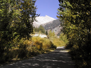
Along the trail to Aspen Flat
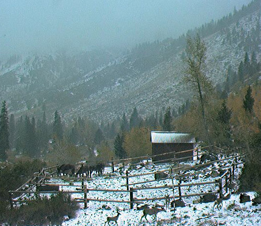
Mineral King Valley, 7830 ft elevation, October 5, 2007 AM
479 comments:
«Oldest ‹Older 201 – 400 of 479 Newer› Newest»awesome pics Daniel!
If that webcam sign says "Thank you Glen" then quadruple thumbs up!
Andy: Ditto! Who are those in the picture, anyway?
Glen: We now have to now scroll to page two on this comment page, because we have over 200 comments. How about starting a new topic??
Sharon
The sign does say Thank You Glen! That is my family. Tom, Wendy, Chris and Courtney Nelson. Gordon's neice and family. We had a great time! Got down to freezing that night. Campground had only one tent and only 2 cabins were in use. We were there on a Tuesday and Wednesday though. Really dry this time of year. No water at the potholes.
We just got back from a lovely 3 day trip. Stayed at the Atwell campground, and yes it did get cold at night! Very peaceful though, not many folks there. Just chickarees, and they were quite fiesty. The aspen trees between cold springs and the honeymoon cabin are just starting to turn.
Photos here
http://www.flickr.com/photos/sierrashadow/sets/72157622425628125/
Hey, winter must be coming . . . the snow pole is up at the corral!
Hiked out to Aspen Flat today, on the way back I saw a directional antenae mounted below the webcam. Looks interesting, what might it be for?
I am not going to steal his thunder, but Glenn has a pretty neat surprise for us!
Might it be anything like this one?
http://www.puc.edu/campus-services/angwin-airport/airport-webcam
If so, my $$$ contributions are on the way.
Mike: You mean a box with a little red x in it? 'Cause that's all I saw on your link. :-)
Big storm coming tomorrow, let's hope for a nice snowfall
Just not too much snow... I want to get in one more hike before they close the gate!!!
The NPS says the road will close at 8 am on November 1st (weather permitting - I assume that means that it will be open no later than that time if it doesn't snow too much before)
Thanks for the constant pic updates during the storm, Glen!
That Tues. 8:58 am shot is wonderful, with the first dusting of snow up there. And raise your hands...who can see the deer?
There's no font size big enough for this "THANKS".
I see deer!
Just in case some of you are unaware what is going on right now PLEASE READ...
Sequoia and Kings Canyon National Parks
News Release
For Immediate Release – October 7, 2009
Contact Adrienne Freeman: (559) 565-3131
Sequoia and Kings Canyon National Park will be preparing an
environmental impact statement (EIS) for a plan to restore
high elevation aquatic ecosystems and mountain yellow-legged
frogs within their historic range in the parks. A notice of
intent to prepare an EIS was published today in the Federal
Register provides more information on the proposal and is
available at:
http://edocket.access.gpo.gov/2009/pdf/E9-24148.pdf.
There are approximately 560 lakes and ponds within the parks
that contain introduced trout, and removal of these
non-native species from up to 15% of these sites will be
considered. This project is needed to preserve and restore
aquatic ecosystems and populations of native species,
including mountain yellow-legged frogs in high elevation
lakes and streams, creating new opportunities for visitors
to experience native wildlife yet also maintaining
recreational fishing opportunities.
Initially public scoping was conducted in early 2007, and it
was anticipated an environmental assessment (EA) would be
prepared to analyze the project. During that time, the parks
received comments from over 30 different sources. As staff
began the environmental analysis and re-examined information
provided by the public, it became clear that the project had
the potential for significant impacts on the human
environment. There was a level of controversy associated
with the proposal, potential for uncertainty and both
adverse and beneficial consequences, and unique and
unforeseeable environmental impacts. For these reasons, in
early 2009 the Superintendent determined that an EIS would
be prepared. An EIS is a more comprehensive document that is
prepared when a federal action may result in a significant
impact on the human environment.
All scoping comments received to date are included in the
official administrative record; the Scoping Summary Report
includes all comments and information obtained to date and
is available on-line at http://parkplanning.nps.gov/seki. It
is not necessary for previous letters to be resubmitted;
however if prior respondents have new issues or information
they wish to bring forward then new letters should be
submitted. The public can submit comments on the project
until November 21, 2009, online at:
http:/parkplanning.nps.gov/seki, by email at
SEKI_Planning@nps.gov, or by writing:
Superintendent
Aquatic Ecosystem Restoration
Sequoia and Kings Canyon National Parks
47050 Generals Highway
Three Rivers, CA 93271
Before including your address, phone number, e-mail address,
or other personal identifying information in your comment,
you should be aware that your entire comment - including
your personal identifying information - may be made publicly
available at any time. While you can ask us in your comment
to withhold your personal identifying information from
public review, we cannot guarantee that we will be able to
do so.
-- NPS --
______________________________________
Why is this such a priority right now? I agree that the frog species should be reintroduced but, how about wait until we have a few normal water years and see what that does for the frog population. Sounds like a big waist of money right now, when both Dept. of Fish and Game and NPS are hurting for $$$$. What do you think?
@Jason Why is this such a priority right now?
Because some environmentalist got a burr up his butt and wants wilderness to be pristine, pure, and "mankind-free." I'm amazed at how the NPS can find time and money to spend on such frivolous things like an obscure species of frog, and can’t find the funds to take down dead and dying trees that are an imminent danger to park staff, park visitors and cabins (whoops, I said the nasty “C” word)!
Situation Normal I guess.... Fish are finally decent size and prospering...lets kill'em because they aren't Native to a specific drainage........and might be the cause of some frog's decline. Even though that frog hasn't had decent water to lay eggs in because of a drought. It would be a shame if someone actually caught something in these waters....What...common sense?? what's that?
Thanks for posting that, Jason.
Wow, what a dumb idea! How are they going to poison just the fish without killing all the other lake critters living in the ecosystem too?
The public scoping comments in the link you posted are an interesting read as well. Here's a gem from one of them:
"Blaming the trout in these high mountain lakes for the decline of the yellow-legged frog is very disturbing for several reasons. You cannot ignore the fact that the trout and the MYLF have coexisted for over 150 years in these high mountain lakes without a problem until the last two decades. The trout didn't
just suddenly acquire a taste for frogs; they have been part of the balanced food chain for nearly 150 years. The root cause of the decline of the yellow-legged frog is not the trout but a worldwide fungus called the Chytrid fungus. Berkley researcher Vance Vredenburg found piles of mountain yellow-legged frogs dead from the Chytrid fungus (chytridomycosis) in the Sierra Nevada two and a half years ago."
Environmentalism is important for all. Remember, without environmentalists around, Mineral King would probably be a ski resort getting it's first snow of the season right now. But nutty hyper-protectionism is not environmentalism. These efforts to "restore" a wild species population by killing everything else is just, well, NUTTY.
If you're interested in the imminent death of another fishery, please visit my blog at http://www.slotrout.blogspot.com/
Thanks for the info; hadn't seen that yet. Yeah, "common sense", where did it go? Why isn't it "common" anymore? :(
NOOOOO! I didn't want snow yet. I wanted to do at least one more backpacking trip in MK. I guess it's not all about me... :)
I do like that the faculty flat cam shows a cabin. Gives a better idea of the snow depth.
@Paso Andy: Yeah, "common sense", where did it go? Why isn't it "common" anymore?
"common sense" and "government"
"oil" and "water"
"conservative" and "liberal"
You get the idea. . . .
Wow, that Saturday Nov. 14 3:59 webcam shot is amazing! That's my desktop background now!
Andy -
I was just admiring the same image when I saw your comment come thru. It is one beautiful view!
Shawn
I am disappointed in the comments about the Park's effort to save the highly endangered yellow legged frog from extinction. The frog has not coexisted with the introduced fish unless it had some refuge and most of the lakes with fish have not had frogs for decades. It is a spectacular frog with a tadpole that does not metamorphose for at least 3 years and it is on the verge of extinction. It is the most beautiful native frog in the state and we only have some 12 species of frogs to start with. Recently an introduced chytrid fungus has wiped out the frogs in the few fish free lakes where they lived. The only chance for it to recover is to replace it in a few lakes that are free of both fish and fungus. I would have thought that people who like to hike in the wild beauty of our park would have more sympathy for this native species. Paul Dayton
Hi Paul,
If the fish and frogs can coexist in lakes where the frogs "have refuge", wouldn't it make sense to try to reintroduce the frogs in those places, and allow the fish to live too? It seems extreme to me to kill one animal off to allow another a "better chance" if they can coexist.
Also, I have come across many Sierra lakes in my travels that were barren of trout. I assume some of them were fungus-free as well. Couldn't these make ideal places to recover the frogs, without killing an established, self-sustaining trout fishery?
It is also true that other species are croaking as we write, and others evolving. Relax and Leave it all alone. Including the
"Controlled" burns.
Mike Dirksen 707-965-2057
How about instead of trying to "fix" everything we just let nature do what nature does? Haven't we interfered enough already?
Stop "re-introducing" things. And yes, stop killing things off as well. We can't undo what's been done, but can't we at least learn from our mistakes and realize that we're not smarter than nature itself and every time we try to "fix" one of our blunders the fix itself is actually just more of the same blundering that got things so screwed up in the first place?
Just stop. Nature will do what nature does. Nature took care of itself for millions of years before we came along. Remember the dinosaurs? They were completely wiped out (more or less) by something, something catastrophic enough to erase an entire way of existence on the planet. Yet here we all are, and here nature still is, doing her thing. Give her some time and nature will take care of us, too.
What's done is done, and doing MORE of it will only make things worse.
Looks like we'll be going to Three Rivers for Thanksgiving. Is there any way that we can get past the gates and drive into the MK area? Weather forecast looks fine, so I don't think snow will be an issue.
Tristan: The Mineral King road gates are closed for the season, and the public is not allowed access to the Mineral King area due to security and safety reasons.
However, ff you are a cabin owner, you may have access to your personal property. If this is the case, send an email to mineralking@earthlink.net for the lock combination.
Well, we decided to just drive up to the gate. Bumpy ride but great views. But really, are four different locks really needed? lol. Definitely trying to keep people out, eh?
Four locks? Hmmm, I'm not sure why. One is for NPS, one for MKDA, maybe one for Silver City residents. The fourth? Maybe utility companies? Beats me.
@Sharon: I'd guess the fire dept has it's own dedicated lock?
Could be the phone company, since they have equipment up there. I'm not sure if the Tulare Co. Fire Department covers a National Park. Doesn't the NPS have their own fire equipment?
I remember two were NPS, one had SC on it (Silver City I'm assuming), but the fourth had nothing
OK, so the "no name generic" must be for MKDA / cabin owners.
Mineral King Webcam needs to create a Facebook fan page...
William, you can always join this group:
http://www.facebook.com/group.php?gid=30732713390
Can't wait to see the cam after this week's storm!
A Musician by Grace
Oh yeah, the pics tomorrow should be great! Hoping for a good snowfall
Now THAT is beautiful!!!!!!
Looks like a snowmobile visited Faculty Flat. Happy new year!
I can't wait to finally see how much snow the MK area has gotten with these huge storms. Looks like we're going to have to wait until Saturday. It's killing me!
WOW!
WOW is right! And another storm is coming in on Monday. I want to see the pole completely covered
Time to strap on the snowshoes!!
Looks like about 7 feet total. Fantastic, should make for a green spring. We'll see you all up there this summer!
I am looking for a picture of the bridge across the Keweah river on Hockett trail. My father worked on this bridge in the summer of 1953.
Hi Emil,
Here is a link to a picture that I took of the bridge about a year and a half ago --> Atwell Hockett Trail - a set on Flickr
Actually, I think that my wife took it, but the end result is the same.
Thank you Glen for the picture link on the webcam page.
The "winter wonderland" pics are fantastic!
Yes, I love the photo gallery! I have some great historic shots that I can send along. How many would you like, Glenn?
A Musician by Grace
Beautiful! That's pushing 100 inches...
And there's another storm forecasted for Friday. I'd like to see that snowpole completely covered
It's great to see such a good snowpack up there. Dare we hope to break 2008's record maximum??
A Musician by Grace
feb. 28, 'The snow in MK - - WOW!!
LOVE IT :) mrm
Woohoo! Beat the old record!
Hoo-ray, we broke the record!
But what IS that thing hanging from the snow pole by the corral??
So, anybody know what is up with the cameras? One with no signal, and the other pic is now three days old.
The Faculty Flat solar panel is probably covered with snow, so it's unable to receive any sunlight to power the camera. The MK cam seems to be fine?
The Faculty Flat phone line has continuing trouble. At the time of the last picture on Friday, the Faculty Flat battery had between 75 and 100% charge.
Does anyone have the stats for the highest snow depth ever in MK? I know there are they ones on the webcam page, but I think those are just since the webcam has been in service. Where does this put us for an average year? I would imagine we are above average.
Anybody have any ideas for transportation for a bunch of bkpkers (as many as 14, maybe less)from Crescent Meadow to MK on Tuesday July 27, 2010. We can pay. We can pay for rental vans. OR we can rent the vans drive ourselves over to MK and you and some friends pick them up at MK and drive them back to the rental place. I'm open to ideas and offers. I just don't want to have to drive from Crescent Meadow to Mk and then home after the end of our 8 day trip. email me:
sierramaclure@sbcglobal.net
I've been trying to figure out the "Unidentified Cabin 1" in the photos section. It's definitely in the West MK area, on top of a hill. It's not ours (stovepipe in the wrong place), and it's not one of the A-frames above us. Perhaps it's the Bree cabin, above the Ranger Station?
If you guys haven't checked it out yet, click on the "Winter Movie" link on the webcam page. Outstanding! Thanks, Glen!
Everyone seen the great photo of the Mt. Lion in front of the Silver City store via webcam.....? AWESOME!
Check the archives for the Silver City webcam... 3/21/10 3:01pm
That is totally RAD!!
Regarding the maximum snow depth; The California Dept of Water Resources has a snow course, #245, in the valley and they measured 184 inches on the ground March 4, 1969 or 184 inches.
My or, means 15 feet 4 inches.
Ah, yes, the "infamous" and deadly winter of 1968-69. There is a first-person account of that tradegy on the MKDA web site; specifically, here:
http://www.mineralking.net/documents/AvalancheQuestMag1979.pdf
I couldn't open the link...
William, sorry about that. Try this link.
Or, go to www.mineralking.net
Click on "About Mineral King"
Click on "Current and Historical Documents Relating to the Mineral King Area"
Sharon
yep, that worked. Can't wait to read it!
NPS website says due to heavy winter snow Mineral King road wont open till june 5th, there goes Memorial weekend!
Robert, can you post the link to where that is stated?
Thanks,
Sharon
Hi Sharon,
It is under the area of the website that shows current road conditions. The link is --> http://www.nps.gov/seki/planyourvisit/road-conditions.htm
Total bummer!
Daniel, I clicked on the link and got
I'm sorry that page could not be found, but you may want to try this park's homepage here: http://www.nps.gov/seki/
I'll try nosing around that site and see if I can find it.
Fiddlesticks!! Well, it is under the road conditions section of the website.
Its under current conditions on left side of www.nps.gov/seki/
Link to current conditions, if it works!! http://www.nps.gov/seki/planyourvisit/currentcond.htm
Not sure how Atwell Mill campground opens before the gate at Lookout Point opens...
Thank you, Daniel, for the link. I'll pass this on to the MKDA e-list.
More snow! Whooo-hoo!
I just spent last week up in Silver City. Conditions were great and yes, there is still a lot of snow on the ground. We were only able to drive in to Atwell Mill and then hiked in the 3 miles. The deep sections of snow where from Boiler Creek to Hockett Trail head and from Cabin Cove to Silver City. On day 2 of our trip, we ran into some Park Service Maintenance Workers. They said the Park was going to start clearing the road this week, but only to the SC housing area. They figured the job would take 3 days to complete. Other than the snow, the road was in great shape. I'm hoping to go back up in 2 weeks.
Matthew, Thanks for the conditions update. Also, the pics by Evan Schmidt of the snow survey were incredible! Can't wait to get up there this summer.
Looks like they've upped the MK Road opening date to June 5th.
http://www.nps.gov/seki/planyourvisit/road-conditions.htm
me and a friend are going to hike out to the blossom lakes in MK over the fourth of july weekend 2010.. want any thoughts on the snow pack this year will it still be pretty thick in july this year?
Yes, unfortunately, there probably will be snow late into the summer. I've hiked in the snow a bit, and on some of the sloped faces 1/2 way across thought, "I oughta have some crampons!"
Looks like the MK Road is now partially open (to Silver City).
That's correct--the road is open to Silver City. However, it is barricated from that point on, because they need to have the road cleared of outside vehicles in order to work on clearing snow and debris.
According to the NPS site here, the road opening is "delayed." But they still have Atwell Mill campground opening on June 2, and Cold Springs campground opening on June 9.
YMMV
It has not been updated on the website yet, but I called the Park Service roads hotliine on Thursday and it stated that all roads in the park were "open."
Here is what the road crew reported yesterday:
"The stretch through Faculty Flat is still a single lane so drive with caution. There will be limited parking through there until the snow melts more.
"There isn't very much bare ground, so the water won't happen for this weekend. We are guessing the week of the 14th, but that is an unofficial guess.
"Avalanche debris off Monarch drainage and Chihuahua Bowl is quite impressive in the valley!"
Does anybody know if Cold Springs (and the MK Road past Silver City) opened on the 9th as planned? The Cold Springs Campground sign at the bottom of the road still said "closed" as of yesterday afternoon.
Received a few days ago from Karl Pearson, Mineral King Sub-District Ranger:
Sharon, I just got word....we hope to have the Cold Springs water system charged by June 26th....barring any problems with the lines. Atwell campground does have water....so folks can fill some drinking water containers there if they are up earlier. Looking forward to a great summer, Karl
I just spoke with the ranger and was told that the road is open all the way to the end. Cold Springs is closed to vehicles right now but is open to walk in camping. Sounds like there is still a descent amount of snow in the campground and the roads in the campground are pretty saturated.
Thanks Ryan!
As of 6/11 cold spring campground is walkin only no water, east loop is mostly snow free, river loop has a lot of snow bound sites still, upper loop is mostly clear and the walkins are still snow bound. Water issues are related to heavy snow year and a new liner having to be installed in the tank at cold springs ...Robert
Bill (William Hart) and I went up to the Mineral King Valley yesterday to do a little recon. Here are some of the pictures that we took when we were up there --> Mineral King, Spring 2010. Plenty of snow on the ground, to be sure. The estimate of one month behind is accurate, as I don't think Cold Springs will be much fun until June 26, which is when the water is turned on anyway.
Wow! Thanks Daniel and Bill. Great pics!
I have an odd question.... Did Mineral King ever have a cemetery? I know my dad has spoke of various graves along the old road and documents he discovered while working for the Forest Service about locations of graves just curious if one existed and if so,where it was located?
Jason, I don't believe Mineral King had an "official" cemetary. I know of a couple of graves that are located up above the existing road, where the former road used to run from High Bridge to Faculty Flat (I have photos of that route, including the gravesite). And I'm sure people and animals are buried around the area, but no official site.
Sharon
As I sit inside my home in
Ridgecrest. with the temp outside at 107, I am thoroughly enmoying the spectacular pictures of the snowy Mineral King area this June!
Thanks so much for sharing them, you all, - for some of us who will never make those treks!!
I look forward to "my " time in MK in July, without snow and a tad warmer :)
I look forward to "my " time in MK in July, without snow and a tad warmer
I hear you, Margaret! When is "your" time, and will you be camping, or cabining?
What a beautiful visit to the Bell/Bates cabin! Was up this weekend, and found only scant patches of snow in Faculty Flat. The river was high, and still lots of snow on the mountains. LOTS of marmots, a few deer, but no bears seen.
Not many cars parked at the end of the road, so I'd surmise not many backpackers yet. The campgrounds were scarcely occupied as well, though the weather was warm and sunny.
We mostly had paradise to ourselves.
Nice shot on the 'cam from yesterday morning. Who are the folks in the photo?
From left to right: Bruton Peterson, Sean Platter, Glenn Cunningham
Thanks, Glenn. Kinda hard to see faces at that size. :-)
Any latest recons up to White Chief & Cirque Caves? We have a trip for the end of July. I'd imagine most of White Chief is still plugged. Snow bridges and creek flows?
Dominic,
I hiked up to the Crabtree cabin ruin meadow a couple weeks ago and the trail was snow free. It seems to be disappearing fast. Did not go any farther than that on White Chief trail, but took some other day hikes on other north-facing trails up to 9500ft and I was surprised how much snow was already gone. The creek crossings weren't bad either. It's probably close to clear now. They'd know for sure at the MKRS 559-565-3768.
OK, who put the "LOVE YOU DAD" sign up on the corral, facing the webcame? :-D
Another question would be "Who took it down?"
Any trail reports? I need my Mineral King fix!
I just returned from a 10-day trip to Mineral King. It was WONDERFUL!! I didn't make it to any lakes this year, but did trapse all over the valley floor.
Weather was perfect (high 30s to low 70s). Go for it, Diamond-X!
Thanks Sharon,
10 days would be paradise, hopefully I'll be there for 3 in a couple of weeks! Maybe fish Franklin or Eagle lakes.
Cheers
Finally made it to Mineral King this past weekend. Temp was down to 37f on Friday night. Camped at Cold Springs which was full, we got the second to last spot. Took the unmaintaned trail to Mosquito #1 then hiked the 'advertised' trail back. Approx 8 mile hike for the 5 of us, Brauts, stove top stuffing and baked beans for dinner! Saw deer, marmots, bear and many visitors. Sunday Morning we did a quick jaunt to Black Wolf mine before the drive home. Kudo's to the great staff of rangers and park personnel who were helpful and knowledgable.
It always makes me a little sad when I see the corral empty this time of the year. It just reminds me that we are nearing the end of the summer season!
@Daniel. Very true. That, and the fact that temperatures are pushing the 30s at night!
I can't believe I have only been up to MK once this year...
Alas, I only made it up once this summer, too, but at least it was for 10 days. It was wonderful!
I only went up for the day at that... Daniel and I went up to do some scouting around for a future trip.
I've done three backpacking trips this summer but none up at MK.
Ahh Bill, such a sad state of affairs! I at least made it for a few days of camping, although I had to stay in the campsite the entire time. We will have to make up for this somehow, don't you agree?
Does anyone know if the scheduled "gate lock" this year is on Nov. 1st? Thanks...
@Paso Andy That's about the normal time, "weather permitting." If you'd like a more specific date for gate closing and water system shut-off, please consider joining the (private) Mineral King email list that I maintain. Contact me at mineralking@earthlink.net
Check it out everyone!! The Farewell Gap cam is up!
Just awesome! Thanks Glen!
Fabulous view, Glenn! Thank you for all your work setting this up. (And thanks to the Crowley cabin family for hosting its location.)
How wonderful to be able to enjoy seeing both Farewell Gap and Timber Gan now! A big thank you to everyone who made it possiable!
like'n the new cam!!!
All I can say is "WOW!"
Awesome!
and snow already. This confirms it....Summer is gone.
Love the Farewell Gap close up. And there's snow! Whoo-hoo, fall is here!
The picture is really breath taking! You can see the trail as it goes out over Farewell Gap! The only way to get a better view is to be there.
Look at the beautiful fall colors starting to appear on the aspen. It's my favorite time of year at Mineral King! Better hurry if you'd like to visit, though--the WMK water system was shut off this week, and the road gates will be locked on November 1.
Snow poles are up and it's raining here. I can smell winter looming on the horizon :)
Went to Mineral King today on my electric bicycle. It was a really nice day, just a tad chilly but nice! Only saw one other person up there, the ranger. Didn't see any animals. The fall colors are here, and a bit of snow. Really beautiful! Photos here: http://yfrog.com/48dscn0002zjx
@JohnR Nice photos! Thanks for sharing! What cabin are you associated with?
@Sharon: I don't have a cabin in Mineral King, I live near Three Rivers and since the road is closed to cars I park at the gate and ride my bike the rest of the way in.
@JohnR You rode all the way from below Lookout to the valley? That's some trip. I bet it was beautiful, though. And today . . . it's snowing at Mineral King, hooray!
Thanks for the pics, John R. Outstanding! Sounds like a fun ride, too.
I'm sure an electric bike would make the trip significantly easier. That's still quite the journey though.
Fantastic pictures from both cams today! Friday 12/10/2010
Nice close-up on Farewell Gap, Glenn!
If you're interested, here's a video of some crazy guys kayaking the East Fork. Wow!
http://vimeo.com/15418258
Nice shot of the storm from the Farewell Gap cam this morning (Dec 19). With this storm, I doubt the batteries will be able to produce any more photos for a few days.
National Weather Service models snow depths at stations around the country. Here's the data for the station (a modeled station, not a physical one) up at White Chief.
http://www.nohrsc.nws.gov/interactive/html/graph.html?units=0&station=WHCC1&x=-118.591944&y=36.421944
Looks like about 10 feet up at 9200'.
David
That is a lot of snow!
Hey! Where's the pole? :D
Happy new year! Looks like mother nature stole the pole
So Awesome! Happy New Year All!
The Shot of Farewall gap looks incredible! I sure would like to see pics of the pisten bully under power.
Happy spring! Doesn't look like the snow is going away anytime soon though
Should be some good snow survey results this year! I hope it warms up a bit in the coming months, or we will be skiing into MK on Memorial Day Weekend!
It's, it's like looking through gauze!
Glen, I just noticed your comment on the webcam page.
"I suspect that the snow level at the Mineral King Webcam site has risen to the level of the camera - 13.5 ft above the ground."
Wow! That explains the current pic. You can tell it's different from when windblown snow covers the camera lens. This is actually a snow drift heaped around the "mailbox" cover that surrounds the camera? Is this a first?
Yes folks, this is the first time that snow has risen to the level of any of the cameras. The Mineral King/Timber Gap/Pack Station camera is 13.5 ft above the ground on the east end of the pack station building. You can see (or could see) how the snow tends to pile up against the east end of the tack shed behind the corral, so it is probably doing the same thing against the pack station building. I'm pretty impressed. I tried leaving the camera on for most of the day on Tuesday, hoping that the heater below the viewing port would warm it enough to melt the snow, but the snow appears to be pretty thick.
I don't ever remember the snow completely covering the faculty flat pole. Looks like there's some more coming tomorrow too. At this rate there should be plenty of snow still around come Memorial Day weekend.
Gona need some real warm weather intervention to get Mineral King ready to open on time this year, last year was bad but this is.. well unbeleivable
I remember the year we couldn't open our cabin until Independence Day weekend. Looks like it might be another year like that one!
Sharon,
What year was that?
Thanks,
Diamond-x
Rats, I knew someone was going to ask me that! I remember it being a driving vacation. I started at Carson City, NV and had to drive north almost to Lake Tahoe before I could cross east to west over the Sierras. I'm guessing . . . early 1980s?
Holy buckets of snow, Batman! Now both cameras are covered? The Farewell Gap snow sensor also stopped reporting in Feb because it has been buried in over 200" of snow!
@ Diamond-X and Sharon - I think that was the year (82-83 is still the snowiest year on record) my Dad took the three of us kids on our first REAL backpacking trip to Franklin Lakes. We couldn't follow the trail in parts and the lake was still frozen over when we got there. It is surprising that I still enjoy it so much after that episode!
Sorry Sharon, I don't mean to cause trouble!
Early 80's was also when both the Glen Canyon and Hoover dam's were almost breached. There was a huge snow pack and a very warm spring rain came and melted it quickly, filling Lakes Powell and Mead to the rim.
A friend and I hiked through a snow cave on the way to Franklin in the early 90's. It was a small valley that had filled with snow, the run-off had melted the center and left the roof, making a spectacular and slightly spooky 100 yard hike through it. Really cool.
I hope there isn't too much damage this year in MK valley.
I love being able to see the valley in all types of conditions, Thanks Glen!
See you all in the Spring, if it ever arrives.
@Diamond-X No worries. I'm just having too many Senior Moments(tm) these days! Sounds like that may have been the same year, maybe '82-83 that Daniel mentioned.
Maybe we should start a pool as to when the gates will open and the water system engaged? I'll throw my guess in as late June!
My memory is fuzzy too, only I can't blame it on a senior moment for a few more years!
Let's see, last year, didn't the road finally open in late May but only to Silver City? Then (if I remember right) it opened to Faculty Flat and Cold Springs a week after Memorial Day, right?
You may be right about June, Sharon. This will be a tough spring of waiting, I'm afraid.
:(
Hoping it'll be opened at least partially on memorial day weekend...was looking forward to head up the road then since I'll be in Three Rivers
I swam in a swimming hole known as "slick rock" in the 1950s. I see pictures of a lake in that area. Did it cover the swimming hole and when was the lake built.
I havn't been back there since.
Emil
@Emil: I believe that you are referring to Lake Kaweah. I don't have firsthand knowledge of Slickrock as the dam was completed before I was born, but I know that my mother and her family (my aunts and grandparents) used to stop there on the way home from Mineral King to swim. She also noted that Slickrock disappeared when the river was dammed in 1962.
Slick rock is still there and still claims lives every summer. Its located in lake Kaweah close to boat ramp #3. Most of the time you can see the rock in late summer when the water is low.
Wow, did we have an avalanche off the corral webcam??
Thanks, Mike, Tom and Keith for re-aiming the web cam!
It's been great having both webcams to look at!
Looking forward to visiting this special place. Will be our 6th year since finding Mineral King. Something special up there...hard to put in words.
Just returned from a 3 day trip up there. We stayed at our cabin in Silver City, but did venture up the road to MK. With the warm weather, the snow is melting fast. Still 5 feet of snow in the shade at Facility Flats. The Park has cleared the road to Silver City, but they said they were going to wait on doing the rest of the road for a couple weeks. Should be a nice, green summer.
Just when you thought the snow was over for the season...
Any word on whether the MK road will be open for Memorial Day weekend?
From SEKI Sub-District Ranger Chris Waldschmidt about the Mineral King Road and WMK/Campground water system on May 15, 2011:
The road is currently passable to Silver City and that area is melting quickly. Park maintenance is working on the road as time allows. It will almost certainly NOT be passable up to the ranger station and Cold Springs area for Memorial Day weekend. We are planning on conditions and access similar to last Memorial Day weekend. Visitor and cabin owner parking will be available as high up as we can find a good turn around and parking location. Cold Springs Campground and the water system has an expected opening date of June 10. The road will likely be passable a little before that. This is a estimated date and if we get a quick melt off
we'll open earlier.
Thanks, Glen . . . I meant to post that to this forum, but you beat me to it!
Any further information will be posted to the MKDA e-list.
Wow, more snow... going to be a short summer :-(
Last Sunday I headed up the MK road and it's a lot bumpier than I remember! I turned around at the park entrance because I didn't want to pay $20 to go further, but even there it was a mix of rain and snow. Looks like there's a chance of more rain/snow for the valley later this week. It's certainly sticking around for much longer this year.
It was fun reading the comments left over the years. This will be the 60th year our family has been going to MK and Silver City. I still think the best route to Big Five is Glacier Pass to Spring Lake and over the saddle to Big Five Lakes. My ex-brother-in-law and I did it when we were in high school in 1959.
I just received an email that the Park has punched the road through the snow to the end of the road at MK. It's pretty tight going through Faculty Flat with limited parking and pullouts due to snow drifts. Cold Springs is still closed until they get the water system running. Although the Park still has barricades up at High Bridge, they will determine tonight or tomorrow on whether to allow public access to the MK Valley.
any word on whether MK is open? The campground? Anybody been on any of the trails? Farewell looks like it may never melt.
Paul
Yes, Mineral King is open, but in a limited manner. The road is open clear to the end. Part of the end-of-the-road parking lot is roped off because it is very muddy. A few sites are open in the Coldsprings Campground, but there is no water and you have to walk in because of the snow melt and mud.
It is still early springtime up there. Trees and bushes have just started to bud out, and there are still snow patches in shady areas on the valley floor.
I walked up to the Eagle Lake/White Chief/Mosquito Lakes trail head. It is very wet/muddy with snow melt. I spoke to the on-duty ranger and he said that on 6/9 one of the rangers tried to hike up and said the trail was mostly melted out to Tufa Falls but after that point found tall (10 ft) steep (45 angles, 8-20 ft across) snow drifts on the trail. A few days later, the ranger I spoke to said he went up, only to be turned back because he couldn't ford the raging streams. Even after the snow drifts melt, the streams may be a problem.
It is very warm in the valley (~72 deg) and the snow is melting fast.
@Paul (and others),
The latest from the Park Service is that the water will not be on until June 24 at the earliest. I have been keeping our "e-list" informed on a regular basis, so if you would like up to the minute news about Mineral King, please consider joining this private, no-spam list by contacting me at mineralking@earthlink.net.
Sharon
Hiked to Farewell gap on Saturday. The snow bridge over the second creek was a bit concerning but made it with no problems. The last bit of the hike was all snow.
Sorry, I posted wrong email in an earlier post.
I received a few requests for the private Mineral King news e-list while I was on vacation (alas, not to Mineral King yet--a train trip to Chicago). I added the names I found when I returned, and just sent out a notice regarding MK road work. If you want to be on the list, and did not receive the email I sent today (6/24), please email me at mineralking@earthlink.net
Sharon
email sent, Thanks Sharon
Does anyone know if the payphone at Cold Springs is working?
I checked the pay phone at the Coldsprings Campground and at the Sawtooth parking lot and both of them work. I didn't check the one at the end-of-the-road parking lot because I didn't want to walk through the water from Monarch Creek that is running across the road. It is beautiful up here!
Thanks Glenn!
Yikes! I heard about this yesterday but didn't realize it was in MK! Read the comments after; the last one is from the hiker.
Hiker spends 2+ hours trapped after snow bridge collapse:
http://www.nationalparkstraveler.com/2011/06/collapse-snow-bridge-traps-hiker-sequoia-national-park8334
Has anyone hiked up to Farewell Gap recently?? A group of us is hoping to begin an extended trip crossing over Farewell on Saturday (16th)...but are getting discouraged by the slow melt seen on the webcam. Any information would be helpful! Thanks, Kristin
The rangers at the Mineral King ranger station have detailed knowledge of the trail conditions, and will be glad to discuss them with you.
Call them between 8 am and 4 pm everyday at 559-565-3768.
Thanks Glenn! I spoke just spoke with a ranger. He said the snow level is still at 9500' and recommends 'snow equipment' (I'm assuming crampons and/or ice axes) to go over Farewell. He also said the creeks are difficult and dangerous to cross, but that the best time to cross would be early in the morning. All great (not happy) information. I'm still looking for some first hand info as well if anyone has any?! Thanks again!
Hi Kristin, I do not have firsthand information on the Farewell Gap trail, but I did hike a ways up the Monarch Lakes trail on Saturday. There is still an amazing amount of snow up there, but nothing that would prevent me from continuing higher. I got up to almost 10k ft before the kids got tired and wanted to go back. I would say that when we stopped, we were looking at 20% to 30% snow. Farewell is fairly exposed, so I would think, and this is purely conjecture, that you would likely be OK this coming weekend. Any experience that you have in hiking through sun cups and the like would be very helpful this year.
I am certainly hoping that the snowmelt continues at a rapid pace, even with this week's cooler temps. The following weekend I plan on going out over Franklin Pass!
Ii hiked to farewell gap one month ago wearing regular running shoes.
Some people have asked me about the white haze that has been in the Farewell Gap pictures for the last few days. It is smoke from the Lion fire which is the Kern River area. The fire can best be seen on: http://sierrafire.cr.usgs.gov/camHist/viewer09.pl?camera=needles_1&lastFrame=true
and details about the status of the fire can be found on: http://www.inciweb.org/incident/2400/
Post a Comment